
South Kingstown
In 2005, the Town of South Kingstown, Rhode Island engaged the ESC to develop a Built-out tool for the Town that showed ultimate town build-out under current zoning densities.
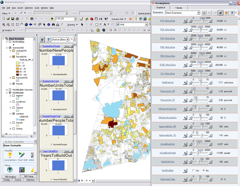
The ESC developed the model in the Scenario 360 extension of CommunityViz so that the model integrated with the Town's GIS. Designed to be automated, so that no "hand-changes" were required, the system was still flexible and extensive, taking into account current development, wetlands, coastal buffer zones, high water tables, existing non-conforming uses and a variety of other assumptions. Assumptions could be turned on or off or adjusted via a "slider bar" so the Town could simulate the effect of policy changes on the results of the Build-Out Model before they were actually changed. The design of the model was developed working closely with Town staff to understand what they considered to be important to how development within the Town actually occurred.
The ESC developed and implemented the model, migrates it to the Town's information systems, trained Town staff and developed user documentation.
South Kingstown is a semirural New England town in Rhode Island. The town has about 30,000 residents and occupies 56.8 square miles of land and 6.1 square miles of water. Settled for over 300 years, the town features a variety of housing types and lot sizes. Administratively, the Town is notable for its active planning staff, a first-rate GIS and GIS manager. The Town has a mechanism in its zoning ordinance that place a limit on building permits as a part of its growth management program.
In 2005 South Kingstown engaged the Environmental Simulation Center to develop a build-out analysis model that would be flexible, repeatable, and easier to maintain and update every year. The scope of work had three major parts: (1) replication of the Town's previous method and output; (2) model design and implementation; and (3) installation of the model and training of the Town staff on operation.
Considerable time and effort went into needs and existing capacity assessment. It also required the ESC to work with the Town's data thoroughly so it could understand the data's limitations strength, and weaknesses.
The ESC developed the model in the Scenario 360 extension of CommunityViz so that the model integrated with the Town's GIS. Designed to be automated, so that no "hand-changes" were required, the system was still flexible and extensive, taking into account current development, wetlands, coastal buffer zones, high water tables, existing non-conforming uses and a variety of other assumptions. Assumptions could be turned on or off or adjusted via a "slider bar" so the Town could simulate the effect of policy changes on the results of the Build-Out Model before they were actually changed. The design of the model was developed working closely with Town staff to understand what they considered to be important to how development within the Town actually occurred.
The ESC developed and implemented the model, migrated it to the Town's information systems, trained Town staff and developed user documentation.
 View Printer Friendly Version